Overview
Project partners are working in collaboration to achieve three main goals. A Stream Channel and Riparian Stabilization Project will implement best management practices to achieve nutrient and sediment reductions, and will be installed along Clifty Creek, a tributary of War Eagle Creek, and within close proximity of Beaver Lake. The Cedar Tree Habitat Project will remove invasive cedar trees along Beaver Lake shorelines and relocate them within lake areas to improve fish habitat and angler engagement. Education and outreach efforts will provide education, outreach and surveys to stakeholders and partners to increase awareness, provide replicable models for additional projects and evaluate success.
Beaver Lake is an aging reservoir, it is over 53 years old and fish habitat is degrading over time. The lake is located in the Southern Appalachians region and increased siltation, excessive nutrients, and lack of littoral structure are priorities for habitat impairments (NFHP Appendix B).
“The citizens of Northwest Arkansas...realize how vitally important maintaining this watershed and this drinking water source is.”
Photo Gallery
Why It Matters
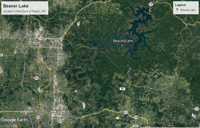
Beaver Lake is an 11,500 hectare (28,000 acre) lake located on the upper White River in Northwest Arkansas. The lake functions as a source of flood control, recreational activity, hydroelectric power generation and is used as a source water drinking supply for over 500,000 people including the surrounding cities of Fayetteville, Springdale, Lowell, Bentonville, Eureka Springs, Harrison and Rogers. Studies by the U.S. Army Corp of Engineers indicate that 4.2 million people utilize the recreational facilities on Beaver Lake annually for recreational activities such as fishing, boating, skiing and camping. Using figures from the Rogers Chamber of Commerce, these activities generate approximately $128 million in local revenue and help support the local economy of Northwest Arkansas.
Threats
Beaver Lake has a variety of habitats, including 450 miles of shoreline. Shoreline habitat varies from shallow sloping mud flats, moderately sloping gravel and cobble banks, to sheer vertical limestone and sandstone cliffs with large rockslides. Historically, standing timber was abundant in some coves, but is now deteriorating as the lake ages.
The fertility of Beaver Lake varies from being extremely fertile in the upper reaches of the tributary arms to being relatively infertile in the lower areas around the dam. This fertility gradient is a function of the high retention time (1.5 year’s average) of water in the reservoir working in combination with varying inflows of nutrients and sediment into the reservoir.
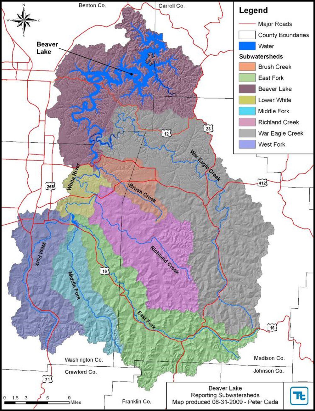
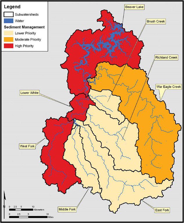
Nutrient and sediment inflows can vary greatly depending on rainfall amounts and agricultural and urban practices in the watershed. The Beaver Lake watershed is 1,192 square miles, and includes portions of Benton, Carroll, Washington, and Madison counties and 17 incorporated municipalities or villages (see Figure 1 and 2). Major nutrient and sediment sources include nonpoint sources such as erosion of stream banks and major county roads, fertilized pasturelands, poultry and swine farms and urban storm water runoff.
Stream Channel and Riparian Stabilization Project
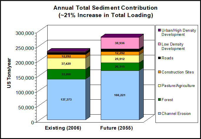
 According to the Beaver Lake Watershed Protection Strategy (Strategy), future annual sediment loading is estimated to increase 21 percent or almost 50,000 tons per year. Without additional protective measures, stream channel erosion is estimated to contribute most (approximately 60 percent) of the sediment load to Beaver Lake. While the decrease in areas categorized as agriculture, pasture, and forest will reduce sediment loading by around 18,400 tons/year from those sources, channel erosion and land developed as low density residential tracts are estimated to increase sediment contributions by approximately 28,850 and 36,700 tons/year, respectively. By 2055, the total phosphorus in the lake is expected to increase by approximately 24,000 pounds per year. As with sediment, the Beaver Lake and War Eagle Creek subwatersheds are predicted to be the largest sources of phosphorus to the lake. The War Eagle Creek subwatershed is predicted to deliver the largest nitrogen load under both existing and future scenarios (See Figures 3 and 4). War Eagle Creek is also listed by the Arkansas Division of Environmental Quality as an impaired stream due to increased siltation and nutrients.
War Eagle Creek has been sampled over the years and supports an average population of Largemouth Bass, Smallmouth Bass and Spotted Bass (Quinn et al 2010). However, major flooding in the creek, which led to increased siltation, was linked to a reduction in catch rates of black bass in 2014. A reduced creel limit was put in place in 2014 (creel limit reduced from 6 per day to 2 per day on black bass).
Invasive Red Cedar Tree Habitat Project
Thousands of standing trees that were in the lake during impoundment have broken down and are no longer available habitat for aquatic species. This loss of fish habitat is occurring in large reservoirs all over the United States (Miranda 2017) and habitat enhancement projects are very important for fish species. Peer projects to reference include a large-scale fish habitat project on Table Rock Lake, located just downstream of Beaver Lake, which placed over 2,000 new habitat sites and greatly improved fish biomass, which increased angler satisfaction and catch rates after the project (Allen et al. 2014). The project was completed in 5 years and over $4 million dollars were contributed towards improvements for fish habitat in the lake. Surveys conducted from the Table Rock fish habitat enhancement projects showed these to be very popular with the angler communities. A professional angler indicated that the project made it easier for fisherman to find and catch fish (Norris 2016). This proposed Beaver Lake project will be just as important and popular with anglers, hunters, wildlife enthusiasts, and nature observers.
What FOR is Doing
Stream Channel and Riparian Stabilization Project
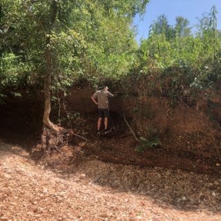
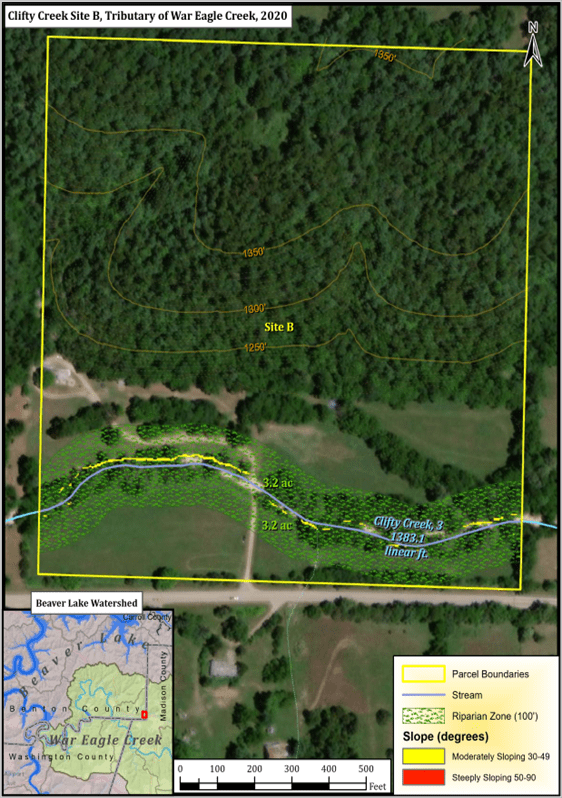
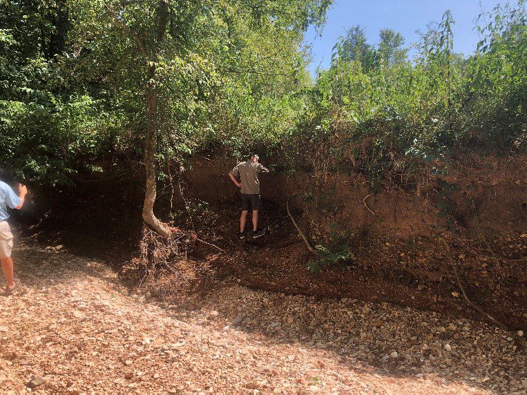
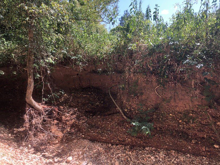
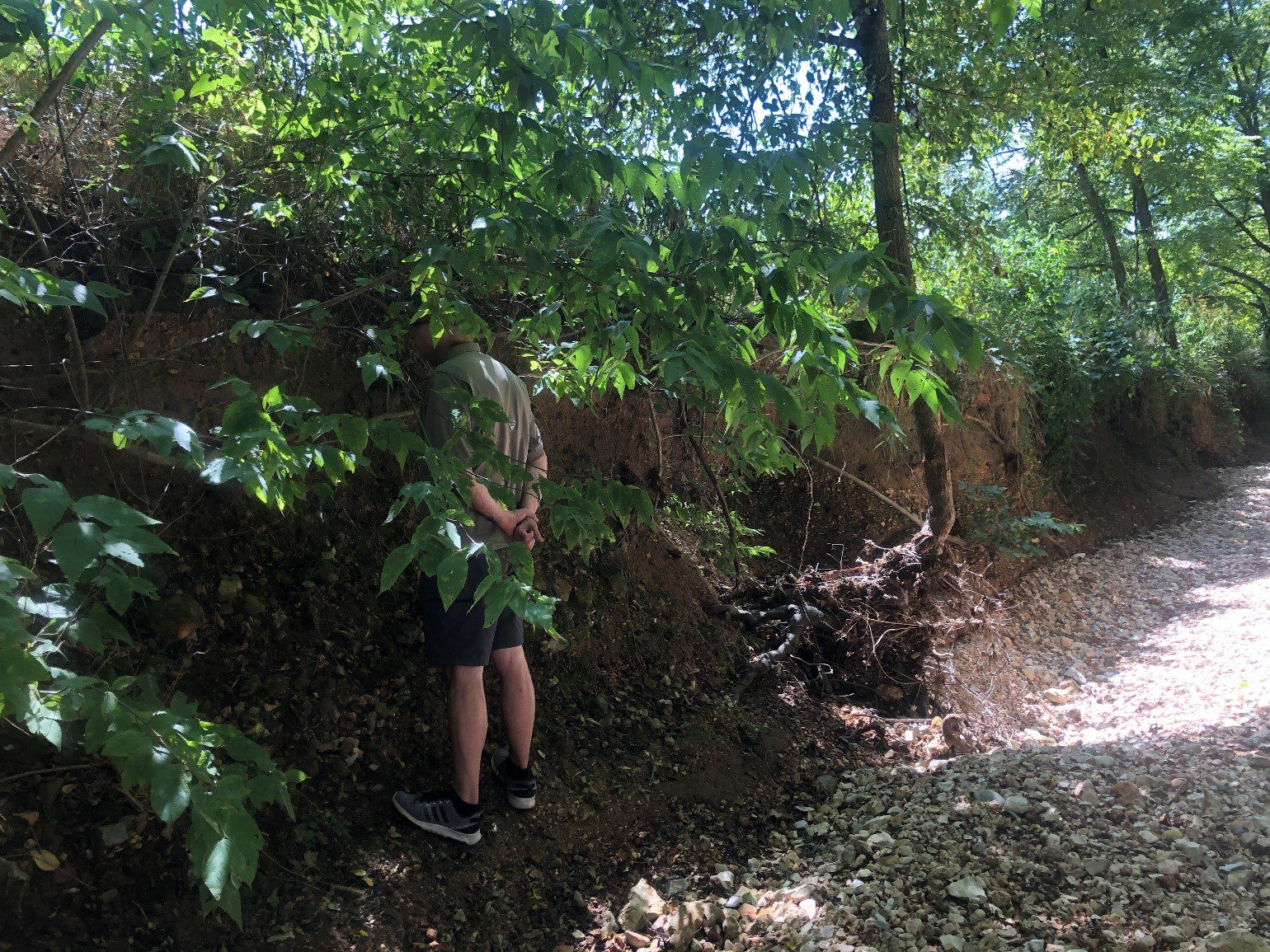
The proposed project will work with landowners on Big Clifty Creek (a tributary to War Eagle Creek) to restore 300 linear feet of eroded stream banks to reduce sediment and nutrient loading into War Eagle Creek and Beaver Lake (See Figure 5). Funds from NFHP will go directly to material for bank stabilization on Clifty Creek utilizing 800 tons of large rock to stabilize stream channel flow and reduce sediments into Beaver Lake and its watershed. Contract services will also include riparian enhancement along the stream restoration, approximately 6 acres revegetated with native plants of the Ozarks.
Invasive Red Cedar Tree Habitat Project
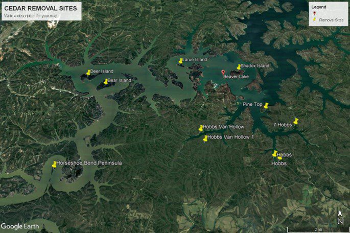
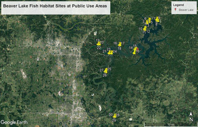
The goals of the Beaver Lake Cedar Tree Habitat Project will be to improve fish, wildlife and glade habitats on Beaver Lake, and Beaver Lake Wildlife Management Area (WMA) by removing invasive Eastern Red Cedar trees from several areas around the lake. Removal of the trees will correspond with a prescribed burn schedule to improve plant diversity and wildlife habitat. The trees will be placed in Beaver Lake to improve fish habitat around the lake. Habitat placement goals include 110 new fish habitat sites on Beaver Lake, thirty sites will be located close to public use areas to improve shoreline angling success and increase access to underserved community groups.
Arkansas Game and Fish Commission will achieve goals of the Invasive Red Cedar Tree Habitat Project by:
- AGFC staff will perform a large scale fish habitat project on Beaver Lake over a two week period from December 2021 to March 2022. The project will incorporate at least 30 employees and 8 barges/boats to place 110 new fish habitat sites in Beaver Lake. Staff will utilize invasive red cedar trees from Corps property to place brush in upper, middle and lower sections of Beaver Lake. At least six large trees will be deployed per site. Standard 8” blocks will be attached to sink the structures.
- A second crew will cut trees from a field below the dam, haul them to the lake and sink for fish habitat. S. Army Corps of Engineers staff will utilize equipment to help load and haul trees.
- AGFC will target points, flats, and backs of coves that do not have any existing fish cover. At least 30 of the 100 sites will be placed close to campgrounds and public use areas to be utilized by shore anglers on Beaver Lake.
All sites will be marked with a GPS and the coordinates will be placed on the AGFC GIS MAPPER Website. https://apps.agfc.com/mapper/#8/34.780/-92.274
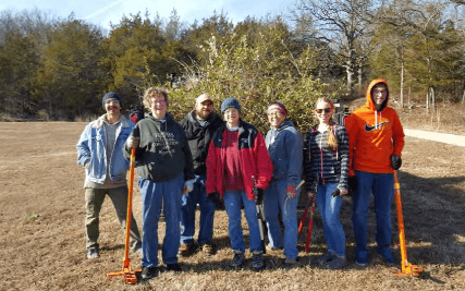
Arkansas Game and Fish Commission will work with Beaver Watershed Alliance to solicit volunteers from the public to conduct fish habitat work on Beaver Lake. The AGFC Fisheries and Wildlife Divisions have fishing and hunting groups (Bear Creek Bass Club, Northwest Arkansas Bassmasters, Quail Forever, Backcountry Hunters and Anglers, the Northwest Arkansas Master Naturalists, and Beaver Lake Crappie Association) that want to provide volunteer help to cut and sink cedar trees in Beaver Lake. AGFC has worked with Beaver Watershed Alliance and Arkansas Natural Heritage Commission in the past to utilize volunteers from the public to help with fish habitat projects on Beaver Lake. Another great project took place in 2013, where AGFC worked with the Arkansas Natural Heritage Commission and Walmart’s Real Estate Division to conduct a large invasive red cedar tree habitat project on Beaver Lake.
Partners will coordinate at least 6 volunteer habitat days on Beaver Lake, where volunteer help will assist in sinking invasive cedar trees in Beaver Lake. The volunteers will help place an additional 20 habitat sites in the lake (a total of 130 fish habitat sites for the whole project). Each site will have 6 large cedar trees and will be placed in 15-35 feet of water. Habitat days will be advertised and publicized on social media and other media platforms, including the Alliance digital and mailed media. The goal is gain public support and cooperation in the fish and wildlife enhancement project. We will utilize at least 80 volunteers and this time will add $12,672 of in-kind contribution.
Evaluation of Cedar Tree Habitat
AGFC will place cedar trees is various configurations to determine which structure holds more fish (based on electrofishing or scuba sampling). Each configuration will have 10 sites to be evaluated.
- Construct large “windrows” of Cedar Trees (10 sites) with 20 cedar trees in natural spawning habitat in the back of coves. Trees will be placed in long lines, parallel to the bank, in 10-20 feet of water below normal elevation. Standard 8” cement blocks will be attached to sink the structures. Goals of these large clusters will be to enhance spawning cover and provide cover for newly hatched fry.
- Place 6 cedar trees in line perpendicular to shoreline ranging from 10-30 feet of water on points, flats and coves.
- Place 6 cedar trees in tight clusters on points, flats and coves.
AGFC will conduct a creel survey before habitat placement (March 2021-December 2021) and 5 years after completion to determine angler preference, catch rates and fishing success on cedar tree brush piles.
Education and Outreach
Education and outreach efforts, provided in part by the Alliance, include quarterly mail outs and digital newsletters to over 20,000 streamside, pasture and forested landowners in the Beaver Lake watershed area. Outreach and education will focus on project partnerships, best management practices used and highlight milestones and successes of the project. Volunteer groups will be notified of opportunities to assist in riparian vegetation establishment. Beaver Watershed Alliance has established outreach channels and volunteer base to achieve this goal.
Related News
National Fish Habitat Partnership Funds Five Additional Reservoir Priority Projects through Bass Pro Shops Outdoor Fund
Our latest batch of projects is official. Many thanks to Bass Pro Shops and Johnny Morris's team for supporting fish habitat improvements in some of the most impacted waterbodies in […]

Coalition receives $3.9 million to conserve, restore War Eagle Creek
A coalition will receive a $3.9 million grant to conserve and restore War Eagle Creek in Northwest Arkansas, U.S. Secretary of the Interior Deb Haaland announced Wednesday. “Nature is our […]
Habitat and fish added to Arkansas waters by the truckload in 2023 | Stuttgart Daily Leader
LITTLE ROCK — Arkansas Game and Fish Commission biologists created nearly 200 semi-truckloads of fish attractors in 2023, and hatchery trucks kept up the pace, pumping more than 9.1 million […]
Green Sponsors
Silver Sponsors
- Arkansas Natural Heritage Commission
- Hobbs State Park
- U.S. Army Corps of Engineers